
Understanding Wetland Delineation Services and Wetland Boundary Mapping
When working on projects that involve land development, construction, or environmental management, understanding the precise boundaries of wetlands is crucial. Wetlands are protected ecosystems that provide essential environmental benefits, including water filtration, flood control, and habitat for wildlife. Accurately identifying and mapping these areas helps ensure compliance with environmental regulations and supports sustainable land use.
In this post, I will walk you through the essentials of wetland boundary mapping, explain what wetland delineation involves, and share practical insights on how these services support responsible project planning.
The Importance of Wetland Boundary Mapping
Wetland boundary mapping is the process of identifying the exact limits of wetland areas on a property or project site. This mapping is essential for several reasons:
Regulatory Compliance: Many federal, state, and local regulations protect wetlands. Knowing the boundaries helps avoid violations and costly penalties.
Project Planning: Accurate maps allow engineers and planners to design projects that minimize environmental impact.
Environmental Protection: Mapping helps preserve wetland functions such as water purification and wildlife habitat.
Risk Management: Identifying wetlands early reduces the risk of project delays due to environmental concerns.
For example, a telecommunications company planning to install new towers in the mid-Atlantic region must ensure that construction does not encroach on protected wetlands. Wetland boundary mapping provides the necessary data to adjust site plans accordingly.
How Wetland Boundary Mapping Is Conducted
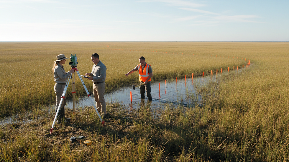
The process of wetland boundary mapping involves several key steps, combining fieldwork with scientific analysis:
Preliminary Research: Reviewing existing maps, aerial photos, and environmental data to understand the site context.
Field Investigation: Visiting the site to observe soil types, vegetation, and hydrology. These indicators help identify wetland areas.
Data Collection: Using GPS and surveying equipment to record precise boundary points.
Analysis and Mapping: Integrating field data into GIS (Geographic Information Systems) to create detailed maps.
Reporting: Preparing documentation that supports regulatory submissions and project planning.
Fieldwork is often the most critical phase. For instance, soil samples may reveal hydric soils typical of wetlands, while specific plant species can confirm wetland presence. This hands-on approach ensures accuracy beyond what remote sensing alone can provide.
What does a wetland delineation do?
A wetland delineation defines the physical limits of a wetland on a property. It is a scientific process that identifies where wetlands begin and end based on three main criteria:
Hydrology: Evidence of water saturation or flooding.
Soils: Presence of hydric soils that form under wet conditions.
Vegetation: Dominance of wetland plant species.
By combining these factors, a wetland delineation provides a clear boundary line that can be used for regulatory and planning purposes.
For example, a construction firm planning a new residential development in the northeast must know exactly where wetlands lie to avoid disturbing them. The delineation report will guide the placement of buildings, roads, and drainage systems to comply with environmental laws.
Wetland delineation also helps identify buffer zones, which are areas surrounding wetlands that require protection to maintain wetland health. These buffers are often mandated by local regulations and are critical for preserving water quality and habitat.

Practical Applications of Wetland Delineation Services
Understanding wetland boundaries is not just about compliance; it also supports better decision-making across various industries:
Government Agencies: Use delineation data to enforce environmental regulations and plan public infrastructure projects.
Engineering Firms: Incorporate wetland boundaries into design plans to avoid costly redesigns.
Construction Companies: Prevent project delays by identifying wetlands early and adjusting construction methods.
Telecommunications Providers: Plan tower locations to minimize environmental impact.
Residential Property Owners: Understand property limitations and protect natural resources.
For instance, a geotechnical engineering firm conducting soil testing for a highway expansion project will rely on wetland delineation to avoid sensitive areas and design appropriate drainage systems.
If you are involved in any project that might affect wetlands, I recommend engaging professional wetland delineation services early in the planning process. These experts bring the knowledge and tools needed to accurately map wetlands and navigate regulatory requirements.
Tips for Working with Wetland Boundary Mapping Professionals
To get the most out of wetland boundary mapping, consider the following recommendations:
Engage Early: Contact professionals during the initial project planning phase to avoid surprises.
Provide Complete Information: Share all relevant site data, including previous environmental reports and maps.
Understand Local Regulations: Wetland definitions and buffer requirements vary by jurisdiction.
Ask for Detailed Reports: Ensure the final deliverables include clear maps, GPS coordinates, and written documentation.
Plan for Seasonal Variations: Wetland indicators can change with seasons, so timing of fieldwork matters.
By following these tips, you can streamline your project timeline and reduce environmental risks.
Moving Forward with Confidence
Accurate wetland boundary mapping and delineation are foundational to responsible land use and environmental stewardship. Whether you are managing a large infrastructure project or a smaller development, understanding where wetlands lie helps protect these vital ecosystems and ensures your project complies with all necessary regulations.
I encourage you to prioritize wetland boundary mapping in your next project. Doing so will save time, reduce costs, and contribute to sustainable development practices that benefit both people and the environment.



Comments