Acer Associates provides fast, accurate utility locating and utility markout services to protect people, equipment, and schedules. Using industry-leading technologies — ground-penetrating radar (GPR), electromagnetic locators, pipe and cable tracing, and GPS documentation — our certified technicians identify, mark, and map subsurface utilities for construction, excavation, and planning projects. Whether you need public and private line locates, ACER, headquartered in West Berlin New Jersey and serving the Northeast and Mid-Atlantic regions, delivers precise, code-compliant results that reduce risk and prevent costly delays.
Key benefits include:
-
Reduce risk of utility strikes and project delays
-
Accurate K- and Q‑level mapping for design and construction
-
Private and public utility locates, including non-marked lines
-
GPR and electromagnetic detection for complex sites
-
GPS and CAD deliverables suitable for BIM integration
-
Certified, experienced technicians and full documentation
Services Provided by ACER
Comprehensive Utility Locating:
-
Electromagnetic line tracing for metallic utilities
-
Passive and active locating, signal injection, and transmitter work
-
Coordination with public utility providers and one-call centers
Ground-Penetrating Radar (GPR) Utility Detection:
-
Non-invasive detection of non-metallic utilities (PVC, fiber, sewer)
-
High-resolution subsurface imaging to locate depth, size, and orientation
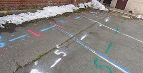
Utility Markout & Field Marking:
-
OSHA- and APWA-compliant color-coded surface marking
-
Temporary and project-phase markouts for excavation, trenching, and site work
Project Documentation & Deliverables:
-
GPS-referenced point data, depth estimates, and confidence levels
-
PDF reports, CAD layering, shapefiles, and integration-ready formats
Why choose Acer Associates:
-
Licensed and certified technicians with industry-standard training
-
Advanced detection equipment and strict QA/QC processes
-
Proven track record across municipal, commercial, and utility sectors
-
Transparent pricing, timely reporting, and responsive customer service
FEATURED PROJECT PROFILE:
Hammonton Water Department
In order to complete remediation activities associated with a former coal gas facility, select utilities at the Water Department property needed to be relocated. A combination of instruments including...